
National Beidou Ground-based Enhancement System "One Network": Sixth Year of Stable Operation
On May 18, 2016, Qianxun SI announced that the National Beidou Ground-based Enhancement System was officially put into operation and started to provide real-time centimeter-level and post-processing millimeter-level high-precision positioning services to the whole society. In 6 years of stable operation, the National Beidou Ground-based Enhancement System has the following accumulation of independent innovation.
The Foundation of Spatial Intelligence Services
The National Beidou Ground-based Enhancement System is the foundation for Qianxun SI to build spatial intelligence services. The National Beidou Ground-based Enhancement System is a major special project of China's second-generation satellite navigation system and an important ground infrastructure of the Beidou satellite navigation system led by the National Beidou Office. The system receives signals from Beidou, GPS, GLONASS and Galileo satellites in real time from reference stations distributed across the country, and transmits them to the National Beidou Data Processing Center through a dedicated network, where the Qianxun SI cloud platform deployed in the data center decodes and broadcasts the differential data in real time. Users can obtain real-time sub-meter, centimeter and post-processing millimeter accuracy location services according to their needs.
As the first one to venture into the "No Man's Land", Qianxun SI's project to build and operate the national BeiDou ground-based enhancement system is extremely challenging. The construction of thousands of stations, covering a vast area of China, is unprecedented for such a technology model in the world. At present, Qianxun SI has completed the construction and networking of thousands of reference stations, and the whole network system uses all domestic equipment, and the core technology, chips and algorithms are all independently controllable.
Autonomous Spatial Server--iStation 18
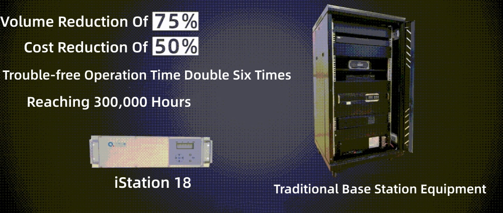
Currently, the national BeiDou ground-based enhancement system "One National Network" has been upgraded to use iStation 18. It has achieved independent control from core technology to algorithms, which guarantees the safety and reliability of high-precision positioning services. Various advanced algorithms of multipath and anti-interference are realized, and the data is encrypted for transmission, so that it can run continuously for a whole year without rebooting or crashing, laying a solid foundation for the stability, efficiency and safety of high-precision services.
At present, the system link reliability is as high as 99.99%, the availability of single station of base station is as high as 99.9%, and the average failure-free time is 300,000
hours.
Ground-based Enhancement Algorithm With Independent Property Rights
The national BeiDou ground-based enhancement system is equipped with independent intellectual property rights of ground-based enhancement algorithm, which adopts grid division mode and distributed architecture design, and supports 16 frequency points of five major satellite constellations with availability rate greater than 99.99%. At the same time, the cloud platform technology provides 7*24 hours high concurrent real-time broadcasting, which has served tens of thousands of UAVs, 100,000 measurement and various engineering devices, millions of smart cars, hundreds of millions of cell phones and IoT devices continuously and stably for several years.
The Road To Industrial Application Of "One Network”
When the national BeiDou ground-based augmentation system was first established, it positioned high-precision services as public services that are accessible to the public and used on demand. This system provides a unified time and space reference for various smart devices and application scenarios, which is the basis for "unified dialogue" of data and enables better coordination among different smart devices in the process of generation and movement.
At present, based on the national BeiDou ground-based enhancement system, Qianxun SI spatial intelligence services cover a number of national-scale applications, and are used in industries such as autonomous driving, smart phones, drones, shared bicycles, dangerous house monitoring, precision agriculture, power grids, etc. Qianxun SI high-precision spatial and temporal services have served more than 1.1 billion people worldwide, with a total service count of more than 2 trillion times. The service covers more than 230 countries and regions worldwide.
Empowered by the national BeiDou ground-based enhancement system, BeiDou is accelerating its deep integration with new technologies such as artificial intelligence and cloud computing, injecting more new momentum for economic and social development. The national BeiDou ground-based enhancement system will continue to be upgraded and improved, laying a solid foundation of stability, efficiency, and safety for more widespread public applications of high-precision services.